People living in cities face a range of invisible but ever-present environmental risks: air pollution, noise, and temperature fluctuations. These risks vary greatly from one street or neighborhood to another. This study presents a solution that allows cities to measure these risks across large areas in real time. How? By leveraging public transport with fixed routes and schedules (buses and trams) to monitor live environmental variables on city streets. Using public transport, as opposed to taxis, ensures continuous monitoring of high-traffic areas that pose a risk to public health due to their steep levels of noise and air pollution, as well as socioeconomically diverse neighborhoods outside of the immediate city center.
Based on their latest paper published in Transport Research Record, ‘Drive-by Environmental Sensing Strategy to Reach Optimal and Continuous Spatio-Temporal Coverage Using Local Transit Network’, part of the Clocking Emissions project, MIT and AMS Institute are currently exploring this approach with the City of Amsterdam. Real-time data can uncover critical insights into environmental risks in different parts of the city, thereby potentially revolutionizing urban planning and policymaking. For instance, identifying neighborhoods heavily impacted by air pollution can accelerate funding for green spaces or air quality improvement initiatives. Precise monitoring allows cities to set clear, measurable environmental goals and track their progress more accurately.
“Although we take Amsterdam as a case study, the power of this research lies in its applicability to other cities.”
Mayar Ariss, MIT Researcher and lead of this research

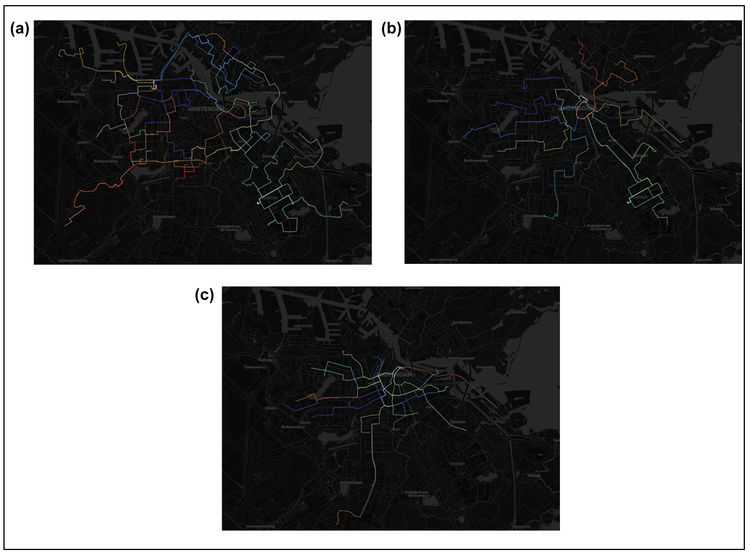
Amsterdam’s (a) daytime bus network; (b) night-time bus network; and (c) day-only tramway network. (Taken from paper).
The benefits of ‘drive-by’ sensing solutions
‘Drive-by’ sensing solutions for buses and trams builds upon previous MIT research where sensors were attached to taxis, initially in New York, (in the Urban Sensing and City Veins projects) to monitor the urban environment. These studies ultimately found that a small number of taxis can cover large urban areas and that ‘drive by’ solutions boast lower deployment and maintenance costs than stationary sensor networks. However, using taxis has its drawbacks. Spatially, for example: taxi’s largely occupy commercial and tourist-heavy areas, thereby leaving huge more socioeconomically diverse areas of cities uncovered.
How does it work in Amsterdam?
The Clocking Emissions project analyzed Amsterdam's transit network, including X buses and Y trams. They identified overlapping segments providing the most spatial coverage and frequent service, minimizing gaps in data collection. Based on environmental literature, they determined optimal sample rates for accurate measurements of various environmental features and assigned sensing devices accordingly, creating an efficient drive-by sensing model.
“The data serve as a reliable basis for evidence-based and better-informed policymaking, enabling city planners and policymakers to formulate informed decisions based on current, accurate, data rather than on anecdotal evidence or outdated studies”
Fabio Duarte, Principal Research Scientist at MIT and Associate Director of the Senseable City lab at AMS Institute

Daytime bus network (a) before and (b) after symmetrized segment-path distance (SSPD). (Taken from paper).
Beyond Amsterdam: the potential for scaling
Although Amsterdam serves as a case study, the power of this research lies in its applicability to other cities. This solution offers real time data far superior to anecdotal evidence or outdated studies, allowing policymakers to set clear and measurable environmental improvement goals. The AMS and MIT team aim to pilot this in Amsterdam, potentially adapting the approach for specific environmental challenges, such as the huge generation of emissions from heavy diesel trucks. Ultimately, any city with a public transport network can adopt 'drive-by' sensing, making this approach highly scalable.
The 'drive-by' sensing solution proposed offers a transformative approach to monitoring urban environmental risks. By leveraging existing public transport networks, cities can gain real-time data to inform smarter, healthier urban planning. If your city is ready to take the next step in environmental monitoring, reach out to our team.